Summer in Florida means thunderstorms, but often the cells are widely scattered and easy to avoid. Will that be the case today? The mission is to fly your Cessna 172 from Orlando Sanford Airport (SFB) up the east coast of Florida, landing at Saint Simons Island (SSI). It should take about 1:15, and while you’ll be able to monitor the weather with your iPad and ADS-B receiver, the flight will be VFR since you are not instrument rated.
ETD is 1700 local, 2100 Zulu. Read the weather briefing below, then add a comment and tell us if you would take off or cancel.
Overview
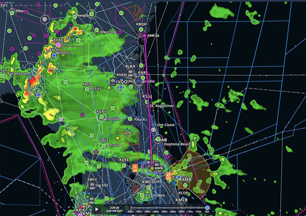
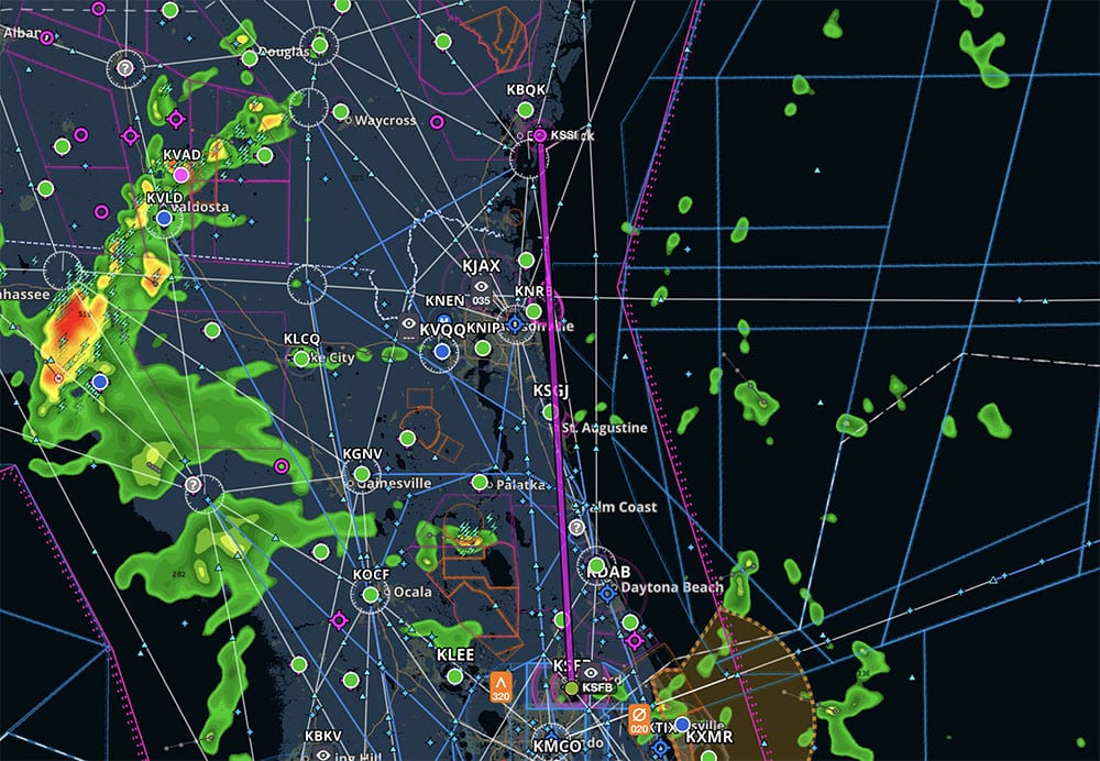
The map on ForeFlight is quite colorful, as you would expect for a summer afternoon in Florida. It looks like scattered rain and thunderstorms are all over the state, with the worst to the south and west of your route.
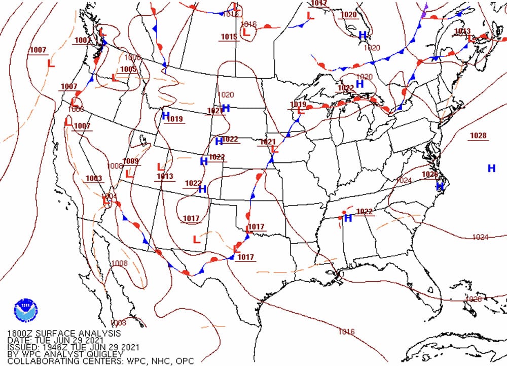
The surface analysis shows the big picture—what’s driving the radar image. The short answer is, “not much.” There’s clearly some instability in the atmosphere, but there are no significant fronts or low pressure systems in the area.
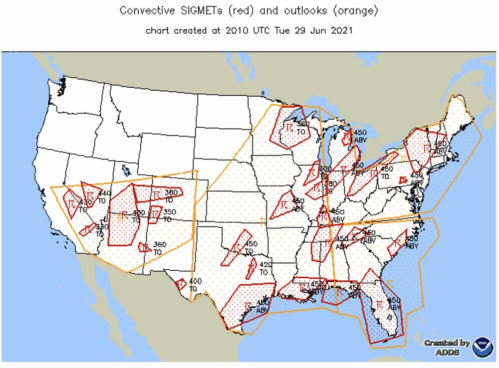
As you would expect from the radar image, there are plenty of Convective SIGMETs around.
Radar and Satellite
For a more detailed look at the rain and thunderstorms, you pull up the static radar image in ForeFlight, which shows the composite radar image for Florida.
There’s a lot of rain over the state of Florida, but much of it in your area looks to be green. This could be a case of high level moisture that doesn’t reach the ground, so you look at the lowest tilt radar image in ForeFlight. Sure enough, it removes a lot of that lighter green, although the storms up by Tallahassee look serious.
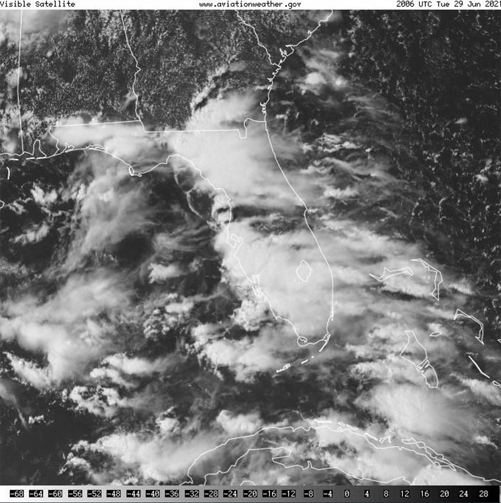
A satellite image is another great tool for determining how serious any rain or storms might be. First, a look at the infrared image shows lots of cloud cover, over almost the entire route of flight. Much of this looks quite thick.
Just as you compared base and composite reflectivity, it’s a good idea to compare infrared and visible satellite images. The visible image shows lots of clouds, but in the eastern part of Florida a lot of those clouds look to be higher level ones—maybe some wispy clouds blown off the top of the bigger storms.
Text Weather
Since you’re VFR today, it’s not enough to consider the potential for storms. Can you stay out of clouds along your route? The good news is that your destination is reporting good VFR conditions, although the TAF shows scattered storms and the METAR has a “LTG DSNT W” note.
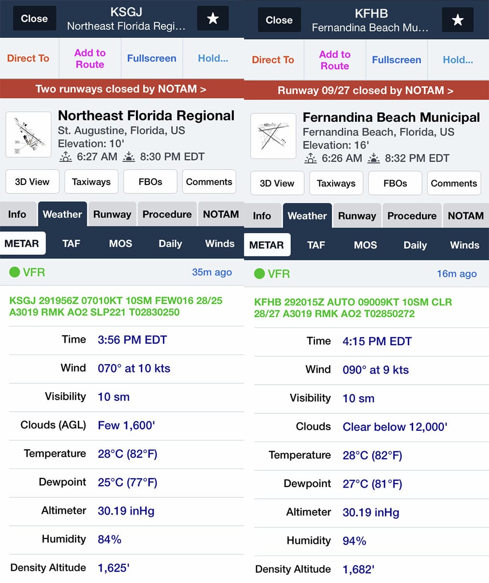
En route weather looks good, with two airports along the coast reporting clear skies.
Your destination is also showing excellent weather, with some gusty winds and the chance for some rain showers.
Decision Time
It’s time to make the call: go or no go? In some ways, this is just a typical summer day in Florida, so dodging an occasional build-up shouldn’t be too hard—the weather is VFR at your departure, en route, and at your destination. But there are plenty of storms around, and some of them look pretty nasty. Plus, your departure and destination both suggest the chance for rain and/or storms.
Add a comment below and tell us what you would do.
- Christmas reading list: 24 books for pilots to read in 2024 - December 6, 2024
- Weather flying means learning to read clouds - November 11, 2024
- What’s wrong with the teardrop pattern entry - September 25, 2024






Pretty easy “go” here. Lots of options for diversions if more cells crop up and they start to coalesce. Pretty flat country to stay visual under the bases. Lots of daylight left. The ADSB weather in this scenario is nice, but doesn’t change the decision-making. This needs to be done with eyeballs more than datalink.
I fly Florida’s East Coast often, and this is a common scenario for sure. My major concern with this is that the weather here tends to move West to East… if you have some wx buildup that’s pushing you East, your being pushed over the ocean unless there’s sure to be ample room to turn left to put it down and wait it out. That’s a heavy gamble, ocean on one side and deteriorating conditions on the other. One risk factor to the plus side is that there’s a number of airfields to put her down along the coast if need be, but still, I prefer flying north/south along the coast without pressing weather to the west.
Typical Florida summer weather. Summers can offer lighter winds and great visibility but having to navigate the thunderstorms is always part of the equation. For any planned cross country trip like that, I like to go either early morning or in the evening after most storms have dissipated. VFR is fine since you can see and avoid the build ups. IFR does give you a few more options not that you would penetrate a storm, but sometimes the best course is through the residual clouds of a dissipated storm after the downdrafts have finished. This of course requires visually seeing the clouds and having ATC’s help. On board weather is also key and I find the ADS-B gives between a 3 minute and 9 minute delay. This is good enough to see what direction things are moving and intensity of cells. Having made the trip from central Florida to South Carolina several times over the past few years, I can tell you I’m still learning a ton about the weather. Set very conservative minimums and only change them as you understand your resources and weather better. You don’t ever want to accidentally get in a Florida thunderstorm. No bueno. You probably won’t be able to tell the story although I’ve heard some from old time pilots who nearly shredded a plane with hundreds of hailstone dents, getting blown from 7k to 15k rapidly despite pushing the yoke full forward.
No way. The radar picture alone is a deal breaker for me.
I would wait until the next morning when most of the convectivity could disappear or be less. I would try to make the flight as easy as possible without testing my piloting skills based on forecasts which can be wrong.
No, find something else to do today and wait for a nice day. This is a pleasure hobby not a test of how risky you can be and still survive.
25 miles in front of the storm is my buffer. Where will the storm be in 1.3 hours plus my buffer. It is better to be on the ground wishing you were in the air than in the air wishing you were on the ground.
I am a new guy at this. (only about 10 hours actual flight time.) So,
for me it would probably be a No Go. But I think this article is very
educational as far as interpreting weather statements and radar.
Seems like a typical kinda day in Florida’s summer or here in the Houston area. I’d say it a “go” decision. The way you briefed the flight was excellent!
I would give it a try. It looks to me like the highest risk is around St. Augustine, and if the conditions upon entering that region were too low ceilings or the convective activity nearby, I would turn around and go back to SFB. ATC has very good weather info these days and are very helpful with advising on precip returns. This makes me glad to have the instrument rating! In Michigan, without that you would only fly a fraction of the time you could otherwise safely go.
No Go. Flying should be fun. This looks like work.
It would be a Go for me. If you wait for perfect weather during the summer in the south you will never fly anywhere. It’s a short flight and you’re flying a c172 that you can land at almost any of the numerous airfields along the coast if you need to divert. The lowest tilt radar is giving you your most accurate picture for this low altitude flight in a c172. The more significant weather is far enough to the west where you can be on the ground at your destination without any unnecessary risk before it is a concern.
But everyone should always do what they are most comfortable with for their own skill set and knowledge. If something inside you tells you it’s a bad idea then listen to it. There are no heroes in this hobby for completing flights.
IF you had your heart set in KSSI at that time of day in Florida I’d encourage a change in plans. It is often substantially overcast in the KDAB-KBQK “corridor.” Conversely, should not be a problem to fly VFR keeping close by and landing at some closer fields so you enjoy the 3 hours or so you appear to have set aside for flying that early evening. Just keep an eye out to the West continually.
Getting to the destination appears to be feasible with a few clouds off to the west and light winds along the way. Destination weather looks like it will hold up for the duration of the flight. Not mentioned in the scenario is the return trip (date/time, etc.). Things may change if that band of moisture moves eastward.
It will.
Based on the data provided (including the PIC is not IFR rated), I would NOT go.
You have a storm system on the west and ocean on the right. If as a VFR pilot you few into IMC, you could find your self out over the water. When you popped out of IMC and only saw water this could be disorientating and adds stress/risk. Being a VFR pilot mean you enjoy flying and are out to have fun. Getting bashed around by storms or having to play dodge ball with weather isn’t my idea of having fun…
Even as a IFR rated and current pilot, I would not go. Sure I have the skills to handle some IMC, but I would still say playing dodge ball with foggles on isn’t my idea of fun :)
Weather can change quickly and unexpectedly. We GA pilots need to maintain a healthy respect for Mother Nature and remain conservative in our ADM, less we see more accidents and thus higher costs (read insurance)…. Like John and Martha King love to say “Use your superior decision making skills so you don’t have to use your superior flying skills…”. Or words to that affect
Decision
No go
Radar picture not good
Your options include getting pushed out to the ocean or running into thunderstorms
Alternate airports though enroute I would not want to be suddenly faced with sudden decreased visibility
Plenty of other days to fly in Florida
If IFR then more options to attempt flight with ATC help
May be next morning. Although the forecast isn’t totally incourageous, a flight in the afternoons in Florida in the summer could almost always turn in encounters with thunderstorms. Don’t forget that the scenery puts a non IFR pilot in command of a 172.
I’m a no, unless I’m ok with sitting it out someplace. I think it is possible to see the weather boil up in those conditions especially late afternoon, they pop up so you don’t see them coming they sort of just appear. Running the coast can offer you better conditions but can also be what creates weather.
I love these mental mind puzzles that put your ass on the line
I really gain a lot listening to your Individual responses
I’m a “go” at this point, with the option to reassess when I get to the airport because I don’t have the data I want to declare a no-go.
If I had the dynamic radar data or the cell vector sticks in Foreflight I would be able to make a better assessment now as to where and how fast the west coast weather is moving. There is high pressure to the northwest and all of the surface winds are easterly, with the pressure gradient lines showing a pressure decrease from northeast to southwest leading me to think the storms would be on a more southerly to southwest track. The TEMPO conditions in the departure and destination forecasts bracket my planned takeoff time, so a real time look at the airport would give me a good idea as to whether or not the conditions had developed and same for my destination. My departure TEMPO forecast is for gusty winds and thunderstorms, so if they’re really there I would abort, or better yet delay if that was an option. A departure after 2200Z would have me out of the TEMPO condition window in both places and still allow me a day landing. Again, depending on where the weather was really going.
THANK YOU
I am a VFR for fun/min-risk guy with low hours. The scenario looked good to me, especially when I saw runway winds at both departure and destination to be from due east and the very mild surface analysis (was my logic totally wrong?). I completely defer to those whose caution and experience say NO-GO. However, how can I fly without a pro evaluating my plan?
Go. This weather looks, as others have commented, typical summer afternoon FL weather, According to the forecast these appear to be airmass thunder storms with little movement. We should be able visually avoid the build ups and remain VFR along the entire route, If a thunderstorm does block our route we can always land and wait it out.
Great discussion, and great comments. I’m not sure what ForeFlight bases it’s composite and low-altitude radar depiction on, so I always take a look at Aviation Weather Center radar images, both composite and base. Satellite images as well. Go/no go decision for me takes into account that info, plus performance of the aircraft I’m flying. If it is CE-172 or similar, options are more limited so that has to be factored in. The other big factor is experience, both flying hours and Florida wx experience. With a good amount of both, it’s a go. If not, wait until the next morning. The fact that several commenters have taken that approach is commendable.
I’m a new ppl and new owner. I would not risk the fun, not risk my life nor risk my plane flying into the path. I learned to steer away 20 NM from the storm so I would wait for it to move in front of me so I’ll be able to steer to the left flying behind it. Great article and great comments.
For me as a new pilot in the northeast, it’s a no go but, I will watch from the ground to see how the forecasts pan out. I’ve had mixed results with forecasts in the past. It’s not easy to make these predictions in some cases but, I am studying the success rates as well as learning to make weather judgments myself.
There is a lot of information missing here. Normal wind in northern florida is from the southeast causing thunderstorms over the center of the state in the summer. Here the thunderstorms are over the western edge. Why? What are the winds aloft at the 3, 6 , 9 and 12K level. TS in north Florida can sit still for three hours, then go to 60K and can move at 40 mph. Will the storms move east? I would like to see why the storms formed and where they were 4 hours ago. Even with a known movement rate, where the storm goes next depends on how the center of Florida heats from 3 pm to dark. Is this adiabatic lifting from the west and the storms will stay there or is something pushing them east. There is no cold front moving down causing the storms.
The surface winds at 070 don’t mean much in Florida. In my opinion as a 20 year Florida pilot, there is not enough information to make a decision. Pictures from Forefront don’t help as much as what did the storms do yesterday, what caused them to form today and where were they three hours ago. Forefront and radar can make you more complacent that you may want to be in a 100mph airplane.
If the storm moves east then it will not stop at the ocean line and can push you 70 miles off shore. Are you sure you want to be there? Making an assumption that you can just land means you can determine how fast the storms are moving and that you can land in a fast moving rain squall with gusts to 30mph. Nothing from the maps answers these questions.
Exactly what I was thinking! Some days the pattern moves E to W, other days it’s the opposite here in the Swamps of Florida… well said.
Yeah – I’d go but timing here is everything and also because I was born and raised in Orlando, Florida and you have to know what to look for and where to fly. My C172R is home to KORL and I fly up and down the east coast quote often, and in and out of KSFB. The mid-summer weather here although not 100% predictable (like an alligator in every Florida lake and pond); you can count on afternoon showers late June through to September..not counting huricanes. A couple things about Central Florida summer weather….as per the author – there is not approaching cold front, and there are a couple of low pressure troughs on the map…but that’s not what is making the weather. Also note that the storm is out of the west and appears to be moving east, while the local METAR winds from the surrounding airports show winds out of the east. (Note also there are no METARs or TAFs for any west coast locations given, something to look at). This is because Florida…and especially Central Florida is home to sea-breeze thunderstorms. Some of them can be quite violent with incredible updrafts specifically when the breezes from the east and west coast meet at the convergence zone in Central Florida. Depending on certain factors for my location, they typically collide along the I-4 corridor between Daytona and Tampa (give or take 30 miles). For your enjoyment, there is a YouTube video of a very prominent YouTube pilot picking his way through Florida sea-breeze thunderstorms, instead of waiting it out at an Orlando airport. With the help of ADS-B weather and Jacksonville approach his continued flight to Texas was uneventful. He did an excellent job – and he was very lucky! Depending on the pressure differential, water temperature, lift index, CAPE, heating of the day and other factors, these storms can appear just about anywhere on the penisula, most often in later afternoon, then finally moving back out to sea or dissipating near dusk.
Probably a no go for me. IFR rating would help just to be able to divert around clouds without any worry about maintaining VFR minimums. The weather does not support in my mind the expectation of clear skies. High ceilings don’t mean that you won’t encounter cells to avoid.
This is the exact type of weather that calls out the need to get that next rating. Makes things so much easier.
I fly out of Fernandina Beach (KFHB) so this is literally in my backyard. What I’ve learned flying down here is that the coastline is a magical barrier. Clouds and storms often form either right on the coast, or inland several tens of miles. If there is no frontal system driving behavior (as in this case) my bet would be those storms out west never move too far and will dissipate long before they’ve reached the Atlantic coast. The high pressure over Georgia will support this, with easterly winds. So for me it looks like a beautiful day to beat-feat over to the coast and enjoy a scenic cruise with the blue ocean on one side and beautiful, but non-threatening, clouds on the other.
I think the 2 TAFs at SFB and SSI are very telling. The planned departure at 2100Z for a 1 hour flight will encounter the worst of the forecast weather. I would either leave in the next few minutes (2000Z), or postpone until tomorrow. In an hour (2100Z) SFB is forecast to be IFR, so you may not even be able to depart VFR. By the time you arrive at SSI, the forecast is MVFR, with 4mi visibility, BKN025, and gusting winds.
I know the TAF is only a “forecast”, but it’s pretty current and a short term forecast, thus usually pretty accurate. Why plan your flight into what is essentially the worst weather expected for the day. My vote is go an hour early (now) or postpone.
Id say go. Below 12000 ft ceilings are normally nice flying in my area so as long as you take off soon ok to go. If you need to come back you need to reevaluate.
And here I thought I was so conservative!
Go.
My first thought is there’s approximately a billion airports along the route providing quick easy bailout locations. If you try and get to feeling uneasy, pick one and park it. Most likely if you’re a regular Florida pilot, these conditions are not new to you. I have assumed that the trip is not purely discretionary for the fun of flying. This trip won’t be the most fun you’ve ever had. But if getting to see grandma is what’s on the agenda, you should be able to achieve that with relatively little risk.
I guess the biggest point here is to remember that the Go- No Go decision is one you make every moment again and again – not just before you start. It’s certainly worth a try. Looks to me like it will no problem, but no forecast is 100 % reliable. Be ready to ready to admit you’re wrong and take action on that decision.
Generally speaking, I’m a pleasure pilot and would prefer to wait until the next morning.