|
Getting your Trinity Audio player ready...
|
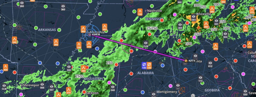
Sometimes it feels like Mother Nature has access to your Flights tab on ForeFlight: it sees your planned trip and places a front right across your route. That’s what today looks like a first glance, as a solid line of rain stretches from Maine to Texas—right in the middle of your planned Atlanta (FTY) to Memphis (MEM) trip. Your Cessna 182 is well-equipped with an autopilot, datalink weather, and a glass cockpit, and you’re both instrument rated and current. Is that enough? Read the weather briefing below and then tell us if this flight is a go or a no go. ETD is 1430Z.
Overview
The flight today will take two hours and ten minutes, with just a five-knot headwind flying northwest, but the radar shows plenty of rain and the METAR symbols show lots of red and pink.
It’s no surprise that the surface analysis chart shows a stationary front over northern Georgia, roughly lining up with the rain.
You’ve seen this episode before, as a front stalls out over the Southeast, and it looks like that might happen again. The prog chart for this afternoon shows rain and scattered storms across a large area.
Even tomorrow morning looks to be rainy and IFR, although the front is slowly moving southeast.
Radar and satellite
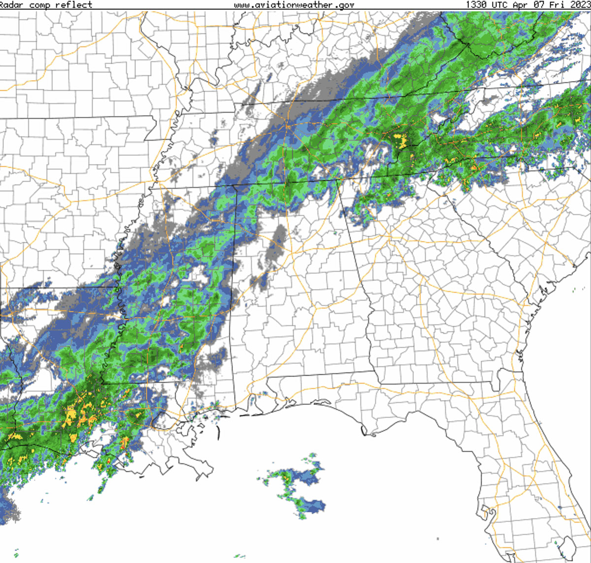
With the big picture in mind, it’s time to look harder at the rain across your route. The regional radar suggests it’s mostly just rain, but there are some heavier spots to the north that warrant attention.
Convection
You know there are clouds and rain, but are there storms embedded in that front? If so, that can quickly derail a flight. Sure enough, there is a convective SIGMET over northern Georgia.
The Extended Convective Forecast Product, valid later this afternoon, shows some potential storms, but south of your flight.
Ice and turbulence
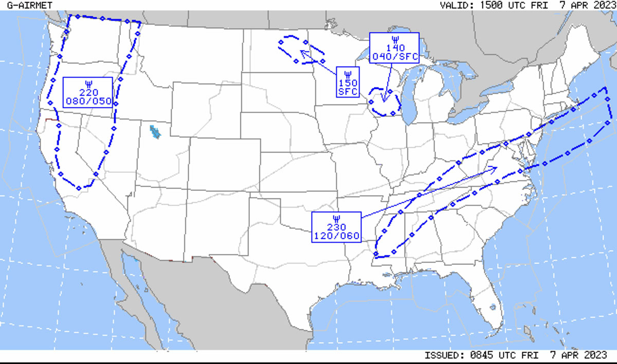
The other threat to consider when the clouds are this widespread is icing. It’s early April, so while not the heart of icing season it is worth checking. There is an AIRMET valid during your flight for icing, but it appears to be mostly above your typical cruise altitude.
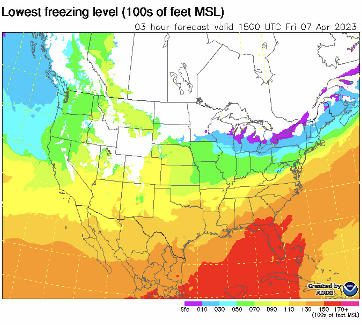
The best news is that you should be above freezing level as long as you don’t go too high.
The icing forecast backs this up, with no icing below 10,000 feet.
Pilot Reports
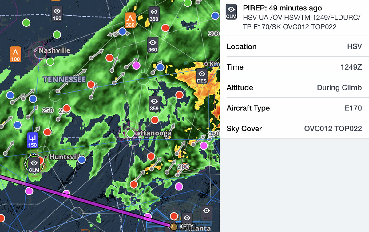
For a more real time look at conditions aloft, PIREPs are always an essential tool. First up is a report right near your departure airport. It shows bases at 1300 feet and tops at 13,000 feet, with a smooth ride and no icing.
Text weather
Finally, it’s time to review the weather at the surface. Your departure airport shows marginal VFR weather, and it should stay that way until tonight, when storms roll in.
En route, there is everything from low IFR (along the first third of your flight) to marginal VFR (closer to your destination). There’s definitely rain out there, although so far at least the visibility is good.
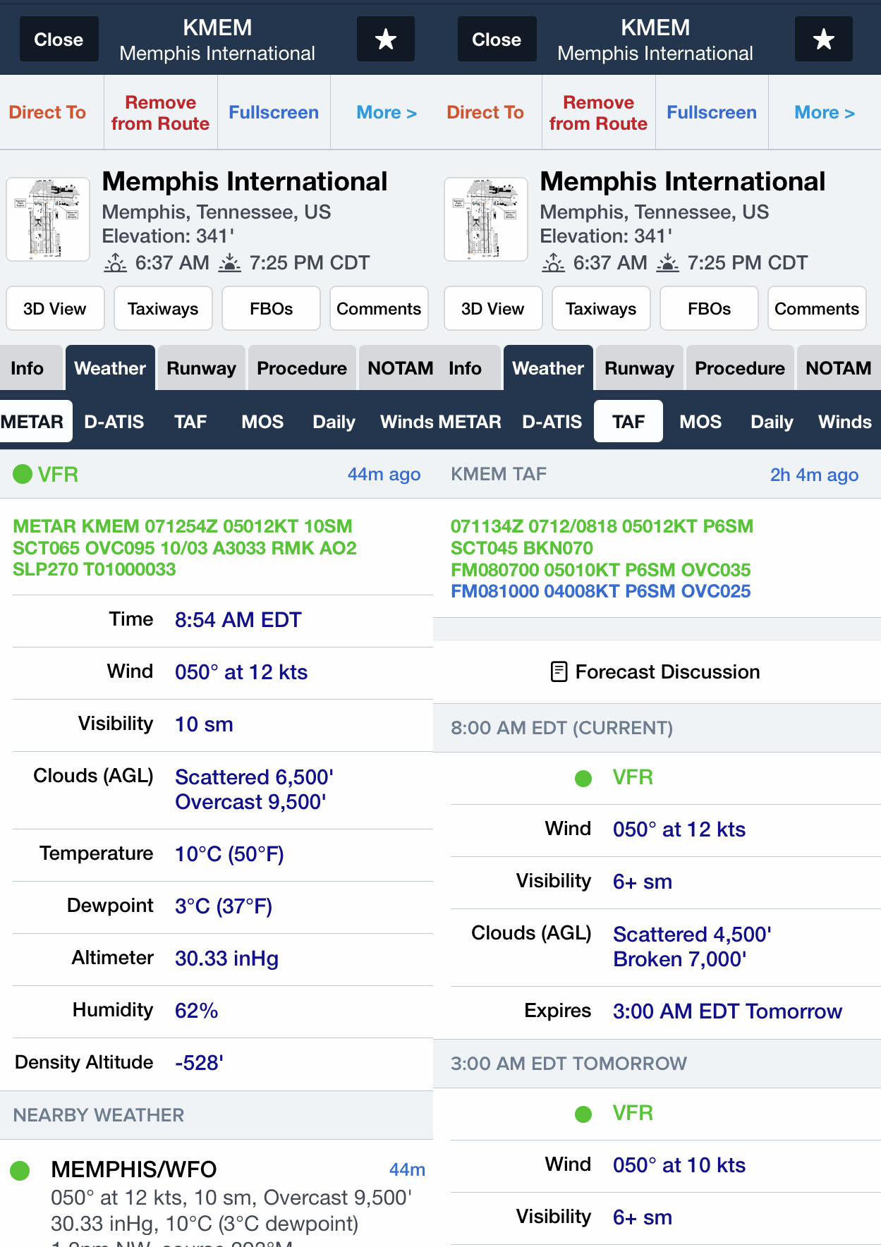
At Memphis the weather appears to be quite good and forecast to stay that way. Finally some VFR!
Decision time
That’s the story according to ForeFlight. You’ll be crossing a weak front, flying in clouds and probably some rain. It’s marginal VFR at your departure and good VFR at your destination, but with plenty of IFR conditions in between. You will probably be below icing, but storms are a potential threat. Is it a go or a no go? Add your comment below and explain your decision process.
- Go-arounds don’t have to be hard - December 8, 2025
- Guard frequency in the age of social media - October 13, 2025
- Why are spatial disorientation accidents on the rise? - September 8, 2025











Anytime there is a possibility for convective activity I cannot see and avoid it’s a no-go for me. Been there, done that, don’t want a T-shirt, don’t wanna ever do it again…
Tough one – with a stout airframe like a C182, convective activity mostly to the north, no ice, a reasonable chance of ending up between layers, and decent outs to the east, this is a flight that could be made.
Tempting… but no. With 2 hours in the clouds and 10 minutes out of it, doesn’t look like a good balance to me for this kind of operation. If it was a much shorter flight, I would go, though.
As a VFR pilot this an easy one. Me and my little RV6 will be staying on the ground.
I’m going to go with Richard Collin’s old piece of advice. It’s ok to take a look see so long as you’re committed to stopping short of the destination if you have to.
Had a similar situation last summer enroute to OSH.
We were equipped with ADS-B in, XM weather and a storm scope.
Worked out, but we were definitely committed to going the long way around if we had to
Assuming the datalink WX shows lightning, I would go with the wise Collins advice above. But pilots only onboard.
I would go. This is an opportunity to log some actual IMC time and there are plenty of outs if ATC reports any heavy precip that I don’t already know about on adsb. Meanwhile, there are plenty of AWOS and ATIS for me to monitor along this route to give me early warning of unexpected worsening weather.
With NEXRAD on board, full fuel and a commitment to maneuver around anything nasty that pops up enroute, including landing enroute to wait out the nasty stuff, and a thorough preflight of the aircraft, this seems like a flight that could be made safely. After all, isn’t this type of weather one of the reasons you spent all that money on the avionics? On the other hand, if the pilot isn’t up for the challenges or is not looking forward to the learning experience that will be added to the knowledge/skill base, then it might be best to stay home today and wait for better weather at a later time.
Pilots who crash in bad weather are often buried three days later in the sunshine! Gravity always wins.
In my younger days(50 years ago) I’d probably takeoff with every intention of diverting at the 1st sign of significant weather. Nowadays I’ll sit on the ground and wait for blue skies. No need rushing to Valhalla any quicker than it’s rushing at me already!
After reading the info, but never experienced any flying in USA I would have to agree with Jim B.
In the East of Aussie the mountains with snow and cold winds can cause problems, winter rain / hail /strong winds give experience however in the west where I have migrated to the only major problem is heat / wind / fog / rain all ok even for VFR planning
I’m a go.
The system is moving from the southwest to the northeast according to the radar presentation. There is currently a narrower band of precipitation southwest of the direct route of flight, so depending on departure timing that narrow band, should it stay that way, could move over my direct route of flight. However, if I’m leaving now I would file with a flight plan that takes me west away from the convective SIGMET area and also south of the Columbus 2 MOA which has a floor of 8,000 feet, while setting me up to cross the line of precipitation nearly perpendicular and with the least exposure. It’s unlikely the MOA is active with this weather but it’s my habit to plan a route that is outside SUA whenever possible to avoid potential reroutes. One of the ATC cleared routes in Foreflight is KFTY WETWO VUZ WASER VANZE3 KMEM, which accomplishes my objectives. But the VANZE3 arrival is for jet aircraft only, so I’d replace that with HLI and be set up for probable vectors to one of the 36’s. I’d file at 8,000 feet to stay below the 9,000′ broken deck and any potential icing. The cloud cover in the area of this route appears to be more hospitable with broken layers for a good portion of it, and then opening up approaching Memphis.
If the weather conditions deteriorate enroute as I approach the line I have KJFX, KHAB and KTUP, among others, as good diverts. I’d plan to reassess the ADS-B weather when I make the turn northwest from VUZ to see if anything is developing in the southwest part of the line and make a decision to divert or continue to monitor, depending on what I see.
I’d go, but would plan a more westerly route initially in hopes of minimizing my rain exposure (hard on the paint). But I’d be flying my Comanche with a minimum endurance of 6 hours at cruise with tip tanks empty and 158 kts cruise speed. Speed and endurance can certainly alter one’s choices, and I’m not that familiar with C182’s.
If you want to be safe, stay away from KFTY. When I went there, I borrowed a crew car for lunch and they recommended that I go quite always north and not go to any local drive-throughs to avoid getting jacked.
After reviewing all the charts I would cancel or postpone my flight in a GA aircraft. If it was that important to get there I would purchase a ticket on a commercial Jet.
One of my aviation mentors told me years ago “It’s better to be down here wishing you were up there than to be up there wishing you were down here.”
For me is a no go. Not because I probably encouter a lot of time in IFR conditions (I’m IFR rated and proficient, happily) in my way to KMEM, or the probability of some convection (that, to me, could, may be, easy to avoid). The problem, for me, was the probability of ice encounter in an a/c with no deice equipment.
After a 39 year career as an airline pilot, I now fly for fun. This doesn’t look fun. I’d go another (better) day.
I would go but would be prepared to divert if weather turned out to be worse than expected. There’s plenty of places to go if diversion is necessary, also we have better in cockpit weather available now for this type of flight. I use both xm and adsb weather.
I was recently in that part of the country on a Mississippi River cruise and experienced horrific thunderstorms from the ground. It was an eye opener, 8” of rain in a short period, hurricane force winds on the ground. I brought ForeFlight with me and the forecast looked like the same as this article. Not too bad. I might have made a decision to go based on my west coast weather experiences. No way now if thunderstorms are in the mix. There no question in my mind, had I inadvertently wondered in a thunderstorm like that I wouldn’t be writing this post. BTW, even the airlines diverted on that particular day.
Wow, what a weird coincidence. I actually flew across this on that day from KECP to KLLQ between 1818Z to 2159Z (deviated quite a bit). Even though my route was south of the scenario route, I figured I’d share this if it’s helpful as a “real world” result of this fantastic thought & planning exercise. Based on the weather shown in the article, obviously I chose to “Go”, and my thought process was stay visual if possible to avoid embedded storms, but: 1) if no yellow or worse is in my path, and 2) no lightning is shown either on the weather display or on my strikefinder, and 3) I am confident based on the cloud types, pireps, and surrounding weather that I won’t fly into an embedded storm, if I can’t stay visual I’ll tentatively fly into clouds and turn around at the first sign of significant ice or turbulence, or any lightning ahead. My airplane is certified for FIKI so that helps some. The plan worked, but added over an hour to my flight time. At one point I turned north (at YARBO) to avoid what I could see visually looked like a minor cell, and ended up turning northeasterly to avoid something else I didn’t like, and then I entered IMC. I picked up mixed ice at 13K’ when I climbed to go odd thousands, so I descended to 11K’ because there was no difference in ride otherwise. When I turned northwest at TCL, I went back to 12K’, and broke out of IMC just past IGB. Overall, the precip was very minor, turbulence was light with 2 instances of moderate (with one updraft that had me 5 degrees nose down and throttled back for about 15 seconds). The clouds were definitely layered, with the freezing level just above 12K’ in northern Mississippi and western Alabama. I asked for a tops report in the vicinity of KMEI and an airliner reported IMC at FL280. The “look” of the clouds was clearly stratified, without much cumulus at all, or I wouldn’t have entered IMC.
This is fantastic – thanks so much for sharing the real world PIREP!
Happy to share, John! So weird that it worked out that way. I saw the weather data you shared and thought, “gee that looks familiar”… Thank you for your well-written, thought-provoking article. What a great exercise.