6th September, 1982.
Flight 420, a Boeing 737 to Hong Kong, departed from a small island on the Equator at about the same time as an unnamed typhoon was born 2,000 miles further west. The depression that spawned the typhoon had been tracked by U.S. Navy weather satellites for several days. As it slowly spun in a westerly direction from 500 miles north of Ponape in the Carolines, the weather forecasters decided it met all the attributes of a maturing typhoon and from a list of names, selected Juliet.
The captain of the flight was an ex-Royal Australian Air Force pilot who had served in Vietnam. The first officer was an experienced ex-GA pilot, who had joined the company from flying Navajos. The remainder of the crew consisted of four stewardesses, who were recruited from island republics in the South Pacific. Two were from Fiji, one from the Solomon Islands, and one from Samoa.
The flight was scheduled to depart from its island base at 0130 local and as usual, the aircraft finally got airborne from runway 33 half an hour late. This was due mainly to a relaxed, informal handling agent who worked practically single-handed to get the 60 passengers underway. The Boeing 737 would touch down at Guam four hours later after a 1,800-mile trip, passing 150 miles to the south of Ponape in the Caroline Islands and an hour later, 60 miles to the north of Truk Lagoon.
During the Pacific war, Truk was a major naval base for the Japanese fleet and a forward headquarters for the Japanese during their drive southward towards Guadalcanal and New Guinea in 1942. Now it is an underwater photographer’s paradise of sunken warships.
I was staying in the Hilton hotel at Guam and received a phone call from our company agent advising that the aircraft was late. Because communications were not always reliable between incoming aircraft and handling agents, I decided to get to the airport half an hour before the aircraft was due.
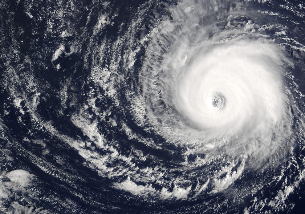
I was particularly interested in the position of Typhoon Juliet although it was still far enough east of Guam as to cause no immediate weather problems for our departure at 0500 local. In two days time, it could well be astride our return route to Guam from Taipei in Taiwan.

Looking for Juliet.
The planned alternate for Guam was the island of Saipan, the scene of bitter battles during the war. The chances were that Saipan could be affected by the typhoon, as the airport was only 80 miles north of Guam. In turn, this meant our payload could be restricted out of Taipei, in order to carry an extra three tonnes of fuel to reach Truk, which was well out of the typhoon’s probable path. It was all too hard for me at that early hour of the morning, and I decided to cross that bridge when I came to it.
Flight 420 landed at Guam and the incoming crew disappeared to the Hilton to rest and await our return two days later. We refuelled to full tanks, loaded more passengers, and departed under the watchful eyes of the United States radar controller for the next sector to Manila. Previously, I had telephoned the U.S. Navy weather forecaster who had predicted that Typhoon Juliet would probably pass between Saipan and Guam itself in 48 hours time. Bloody great, I thought…just in time for our arrival.
The sun rose behind us as we climbed at Mach 0.7 to 31,000 feet and we received the usual cheery farewell from the radar controller as we passed off his radar scope two hundred miles away. Little did we know that two nights later, around midnight, amongst lightning and thunder, we would be relying heavily on that polite gentleman to keep us out of the storm brewing to the east.
En route Guam to Manila, we passed well to the north of the beautiful remote islands of Yap and Ulithi. Ulithi Lagoon was a huge US Navy base in 1945, supplying the fleets for the Okinawa campaign. Yap NDB gave good bearings and we confirmed the accuracy of our position with the combined use of INS and Omega VLF.
Despite the feeling of early morning fatigue, both the First Officer and myself could only sit back and gaze at the dawn of a new day, with the rosy pink hue of the clouds below, the occasional towering cumulo nimbus clouds and the vastness of the blue Pacific.
The Inertial Navigation System (INS) steadily clicked up the passing of meridians of longitude and I plotted the coordinates on the Jeppesen chart. It was probably an unnecessary chore, but it kept my conscience clear. It is all too easy to lapse into complacency, when one is tired. We turned a few degrees starboard for the last few hundred miles of the air route to Manila, and called Manila Control on HF for a clearance to enter their air defence zone.
Penetrating the ADIZ without a clearance was not a good thing, because one could be arrested on arrival at Manila, with little option except to bribe oneself out of trouble. We could even be buzzed by an intercepting fighter, if the Air Force could find a serviceable one!
A small cross on my chart reminded me that we were now passing high above the final resting place of the U.S. cruiser Indianapolis, which was the last major warship lost in World War II. It was torpedoed by the Japanese submarine 1-58 on 30th July, 1945, in the closing stages of the war. It was the Indianapolis that had transported the two atomic bombs from USA to Saipan, from where they were dropped by B29 bomber on Hiroshima and Nagasaki. From Saipan, the cruiser had sailed to the Philippines and had been sunk on the return voyage to Guam, with the loss of 1500 lives.
In the many hours that I flew over the Central Pacific, I never failed to quietly think of the ships and their crews who died in naval battles far below. I think many peacetime aircrew who fly the Central Pacific routes probably feel the same way and it hits one most as the sun rises in the eastern skies, reflecting on the peaceful scene of hundreds of cumulus clouds. Like miniature fairy battlements of cotton wool, they floated above the brilliant hues of coral reefs which appear magically in the distance and slowly pass from view under the wings. It is often a time for reflection.
The First Officer flew the approach into Manila. As usual, we were held high at 4,000 feet by Manila radar, until only a few miles from the runway. This meant slowing the aircraft to the approach configuration early enough to avoid hurried last minute lowering of flaps and wheels.
This annoying problem occurred because ATC were constrained by strict noise abatement rules over the suburbs of Manila. Heaven knows, Manila was already a city of noisy buses, trucks and cars, so noise abatement for aeroplanes was a bit of a joke. The twin needles of the ILS came together nicely and we touched down at 125 knots, only to be subjected too much swaying and bouncing on the uneven runway.
A few months previously, I had flown into Manila for landing on runway 24. ATC had again delayed our descent from 4000 feet, which should have put us uncomfortably high on glideslope. Now the ideal angle of approach for most jet aircraft is 3 degrees. This allows a reasonable compromise between an acceptable rate of descent of around 800 fpm, and ease of flyability.
Anything more than 3 degrees involves a high rate of descent near the ground, and a lot of inertia and energy to be changed for the round out for landing. What puzzled me at the time was that the glideslope needle showed that we were on the correct angle of 3 degrees. This was clearly incorrect, because at our distance from touchdown of 7 miles, the 3 degree slope should have intersected our path at 2100 feet, yet we had only just left 4000 feet.
I suspected that the Manila ILS ground equipment was faulty and that in fact we were flying down a false glideslope of at least 5 degrees or more. A quick check of our rate of descent of nearly 1,600 feet a minute — twice the normal acceptable safe amount – confirmed my thoughts. I decided that if the aircraft was not stabilized and nicely set for landing by 500 ft. we would climb away for another more leisurely approach, using a different navigation aid.
We broke out of cloud at three miles from the runway and concentrated now on establishing a reasonable glide path by switching attention from the instruments inside the aircraft to the lights of the VASIS (Visual Approach Slope Indicator System). These are placed either side of the runway and give a varied pattern of different colours to indicate that the correct approach angle is being used.
Both the F/O and I were surprised to see a meaningless jumble of lights from the VASIS, and I thought to hell with this nonsense and completed a normal landing, albeit further down the 11,000 ft runway than desirable.
As the 737 was being prepared for the final leg to Hong Kong, I phoned Manila ATC and suggested that they take a look at their ILS system as it seemed well outside acceptable tolerances. Additionally their VASIS was up the creek. I found out later that the VASIS installation (several boxes of lights attached to concrete bases and carefully levelled at 3 degrees by means of adjusting screws) had been seriously disrupted by recent earth tremors.
Despite crazy angles now emanating from the displaced light sources, it was “standard” procedure to always have the VASIS switched on for landing aircraft! There were no NOTAMS warning of the unreliability of the ILS and VASIS.
Later that day, a flight check by a calibration aircraft, confirmed that a false glidepath did exist at 5.5 degrees and steps were taken to adjust the beam down to 3 degrees. Two years previously, a China Airlines Boeing 707 had crashed just short of runway 24 at Manila after pressing on to land from a very high rate of descent in perfect flying weather. I wondered if he had tried to fly the same false glideslope that we had located, and simply blindly followed the ILS needles, instead of cross checking with other available instruments.
We landed at Hong Kong a few hours later and after two days of whatever one does in Hong Kong on layovers, we took off for Taipei and Guam at 1600 hours. Typhoon Juliet had by now passed over Saipan, causing damage to the airport instrument approach system. Scratch Saipan as the alternate airport for Guam!
The typhoon was heading southwest at 15 knots and if it continued on its present track, would cross the airways route from Taipei to Guam, around 450 miles west of Guam. Our calculations indicated that on leaving Taipei we would be heading directly towards Juliet, with an ETA over the centre at midnight.

The radar is working, right?
However the 737 was equipped with modern weather radar, and I had no qualms about picking our way between the inevitable storm clouds that surrounded the eye of the storm. The thunderstorms associated with tropical typhoons could reach over 45,000 ft and with the extra fuel aboard needed for our planned alternate of Truk, our cruising level to Guam of 33,000 ft would not clear the tops around Juliet.
Arrival and departure from Taipei proved uneventful and we settled down for the four hour night leg to Agana airfield, which serves both civil and U.S. military aircraft at Guam. The huge Strategic Air Force base at Anderson Field was only a few miles up the road from Agana, but too close however for use as a weather alternate.
The winds aloft were as forecast and I set the radar to scan at 180 miles. We knew that when the first storm clouds appeared on the edge of the screen, it should give us 20 minutes warning to evaluate our course of action. This could mean diverting up to 100 miles off track if the storm cloud area was massive.
On the other hand, by careful interpretation of the radar returns, it may be possible to weave between individual thunderstorms. Much depended on the experience level of the pilot, particularly in radar knowledge. Slipping between storms can save fuel and time, but the passengers are up for a savage ride if the storms close in on the aircraft at the last minute. Radar is used to avoid storms, not to penetrate them.
Two hours out from Taipei and we were cruising in thick cloud. It was a black night and because of this we had no chance of seeing anything up ahead visually. There were no returns on the radar screen, except a few flecks which could have been sea returns. Guam weather was now clear, although ATC advised that lightning was visible on the western horizon.
I adjusted the radar tilt control, moving the antenna down a few degrees towards the sea. Normally the sweeping radar beam would reflect back from big waves, but all seemed quiet down below. By now, the INS began to show a steady wind direction change indicating the upper air effect of the swirling gales on the surface.
By now there should have been some storm cells beginning to show up on the screen, but the night was deceptively calm. I switched on the landing lights to see if the cloud was really thick, or merely high level cirrostratus.
That was a bad decision on my part, as the F/O and I were momentarily blinded by the reflected glare from solid cloud whipping past a few feet away. Too late, we had lost night vision and it was now useless to peer through the windshield into the darkness looking for a close up thundertop anvil.
A stewardess gave us yet another coffee and I asked how all the passengers were. In the past, some had become rather drunk on long flights and had been a real nuisance. I was relieved when the stewardess said that everyone was well behaved. I recall that during one flight from Hong Kong to Taipei, one particular seaman had constantly demanded more booze and seemed to enjoy stirring up the stewardesses as they walked past his seat.
Finally, the senior stewardess complained to the captain about the man’s behaviour. The captain warned the offender to lay off. Despite the warning, the man continued to worry the cabin crew, and again they complained to the captain. Handing over control to the first officer, and just before descending into Taipei, the captain returned to the back of the cabin and calmly told the Pacific islander that unless he apologized to the stewardesses, and acted in a more sober manner, the man would be in dead serious trouble.
The passenger considered himself a bush lawyer, and arrogantly demanded the course of action the captain had in mind. The captain then told him that arrangements would be made for the Taiwanese police to meet the aircraft on arrival. After that, the police would take the passenger away and torture him a little. This threat had the desired effect, and the passenger became a model of good behaviour all the way to his destination in the Gilbert Islands.
Our own passengers had just settled down for the night when without warning, the aircraft hit severe turbulence. The F/O quickly turned on the ignition switches which would minimize the possibility of an engine flameout. There was a frightening blow to the left side of the aircraft from a sideways gust, followed by massive buffeting.
It was obvious that we had flown into a storm top which had not shown up on the radar screen. I made an immediate announcement on the cabin PA system for passengers and cabin staff to sit down and put on their safety belts. Seconds later the cockpit was lit up by St. Elmo’s fire with tiny dancing flames of static electricity covering the windscreen and streaming off the windscreen wiper blades.
The turbulence became severe, with vicious gusts from all directions, and I concentrated on keeping the wings level on the instruments, whilst allowing the aircraft to ride out the turbulence with its own natural stability. The radar screen continued to emit its normal soft green glow indicating a storm free sky. In fact it had probably failed an hour or so earlier while Typhoon Juliet was still beyond the long range scale.
Certainly I was no slouch at radar use, but I had never experienced a subtle equipment failure like this one. We were now up the proverbial creek without a paddle…namely a serviceable weather radar. The turbulence was still severe, as I carefully banked the aircraft starboard on to a compass heading of 180 degrees.
The latest position of the typhoon centre had been relayed by satellite to Guam ATC, who had passed this vital information to us by HF radio. Fortunately I had then drawn Juliet’s position on my coffee stained plotting chart. The position of the eye was 50 miles to the port of our track, so a southerly course would be a safe bet. Put another way, we were already flying blind without radar with all the attendant worries about being clobbered by unseen storm cells. But at least we were heading away from the typhoon.

At least lightning makes the tops easier to see...
Vivid flashes of cloud to cloud lightning rent the heavens and I took the opportunity to look for ice on the wings as they lit up from reflected flashes. In fact the presence of continuous lightning was a blessing in disguise. Each flash lit up the skies like daylight, enabling us to see the towering storm tops outlined for a frozen moment in time. Some were like battlements high above our cruising level — others were lower, but ominously building at 1000 feet per minute.
Whilst the F/O steered the aircraft on automatic pilot, I kept my nose against the windscreen directing the F/O for last minute course changes. A flash would illuminate a dark monster 30 seconds ahead. Another flash would expose a clear patch 20 degrees to the right, and I would call steering instructions like a bomb aimer running into the target.
I still couldn’t believe the radar had really failed, and in between visual tracking between the now isolated storms, I tried to troubleshoot the problem. Even the F/O who was an electronics whip was unable to rectify the fault, so we reluctantly switched it off.
By now we had advised Guam ATC of our predicament, and we were cleared to divert from the air route by 100 miles. Eventually, the lightning faded behind us, leaving us without nature’s illumination. A glimpse of stars above indicated that a climb to 35,000 ft might get us above the clouds. ATC gave the OK, and soon we were on top of high level cirrus.
With Juliet safely behind us, we altered course towards Guam and called for more coffee. The Samoan stewardess arrived with the goodies, and said how much she enjoyed the turbulence and the lightning too, and could we arrange more of the same! The F/O and I looked at each other, and told her she must be crazy.
She then explained she was new to the job and was still very shy of talking to passengers. When the seat belt signs were switched on at the first turbulence encounter, it gave her the ideal excuse to disappear to the rear of the cabin and ignore the call button chimes of the frightened passengers. Good thinking 99, I thought. That girl has got initiative!
An hour later ATC radar picked us up 200 miles out to sea from Guam. We were very relieved to recognize the voice of the radar operator and we requested radar vectors around any heavy clouds. At one hundred miles out we broke clear of clouds into a typical Pacific moonlight night and sliding down the ILS we touched down safely on runway 06 Left. An hour later the first of many beers at the Guam Hilton hotel never tasted better.
- Like overtaking on a blind corner and hoping nothing is coming the other way - June 17, 2019
- Flight directors – a fatal attraction - April 18, 2018
- The day I learned I’d never be a fighter pilot - September 22, 2016


")


Sweet!
Very well written and entertaining, I enjoyed that.
A few more on the way (and I don’t mean typhoons)!